+2.jpg) Geographic Location
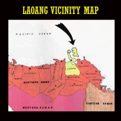
Geographic LocationThe Municipality of Laoang is located at the northeastern portion of Eastern Visayas or Region VIII, it is bounded by the Philippine Sea in the north, by the Municipality of Palapag in the south, and by the Municipality of Pambujan in the west. When viewed in a map Laoang can be located at the following coordinates: longitude, 125º 01´ east and at latitude 12º 31´ north. The Municipality of Laoang has 56 barangays seven of which can be found in the Urban Center.
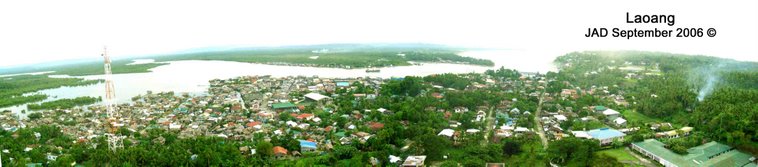
The urban center which comprises 7 barangays is located at the central part of the municipality. Six of these barangays are located in Laoang, while the other one, Barangay Rawis is located at the tip of the island of Samar – the second largest island of the archipelago. It is some 50 kilometers away from Catarman, the capital province of Northern Samar.
Land Area
The Municipality of Laoang is located in the northeastern part of the Province of Northern Samar. It comprises a portion of the mainland of Samar and the three islands of Laoang, Batag and Cahayagan. The bigger portion of the land area of the Municipality is located in the mainland portion, while the rest are distributed to the previously mentioned islands.
Based on the profile of the Province of Northern Samar released by the Provincial Planning and Development Office and that of the Department of Environment and Natural Resources (DENR), the Municipality has a total land area of 24,841 hectares. This figure is distributed to the built-up area, forest land, open grassland, land fill, open water spaces (rivers, creeks, lakes and seas), swamps/marshes/fishpond and its road network. Of this area only 396.4661 hectares or 1.6% of the total land area belongs to the urban center, while the largest portion of 24.444.53 hectares or 98.4% of the total bespeaks of the of the area covered by the rural barangays.
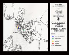
Places of Interest
The Municipality of Laoang has several existing tourist spots sadly Laoang is not listed as one of the priority areas for tourism development by the national government. Thus, development of the tourist sector is laden upon the Local Government Unit but until now there is no comprehensive plan for it.
Some of these spots are natural and some are manmade. A few of these tourist spots are located in the Poblacion or the town proper while some are in the rural barangays. All Identified tourist spots in the Poblacion are manmade. These, actually are a part of the cultural heritage of Laoang, as these are either historical site, a historical building or a historical landmark.
Historical Landmarks
The Saint Michael Parish Church – where the patron St. Michael is enshrined. Built in 1963 by the Franciscan Friars through the force labor, its walls are two meters thick of cobblestones with two side’s altars on both cruzadas. The main façade is graced by the century old statue of St. Peter and St. Paul. A top of the façade is the guardian of Laoang the statue of St. Michael the Archangel and on top it is the Beautiful statue of the Blessed Virgin Mary.
 Photo by Rev. Fr. Gervacio R. Osias
The Muralla – a Spanish period Perimeters fence made of cobblestone that covers almost entire cemetery. It was constructed in 1880 and still resolutely stands in spite the vicissitudes of time. The Muralla is a mute witness to the undying spirit of the people of Laoang.
The Pergola – It is a cobblestone arc reminiscent of Spanish architecture. It was used as a passageway to the defunct “Casa Tribunal” replaced by a present day municipal hall, built in 1894 by then Gobernadorcillo Don Juan T. Mulleda.
The Grand Canyon – or the “Inogkahan” to the Laoanganons, which means excavated space, is a man-made shortcut pass through the Tumagingting Hill. It was excavated in 1913. Its dimension is 5 meters wide, 85 meters long and 5 meters high. On the wall at the eastern side is a “foxhole” dug by the Japanese soldiers sometime in 1942. It is now closed due to hazard that may be brought if the hole is left idle. This pass, now a portion of the cemented road at Capitan Domingo Adoro St. is named after the Capitan Municipal who then spearheaded this gigantic project.
Natural Tourist Spots
The Onay Beach - Scimitar-like beach facing Laoang Bay with bracingly cool blue waters on fine white sand ideal for swimming, surfing and snorkeling; lined with swaying coconut trees. Below the tress are cottages and nipa huts intended for tourist and excursionists, about 1.68 km northwest of the town proper. It is frequently visited by the town folks of Laoang, as well as, residents from neighboring towns like, Catubig and Las Navas especially during Saturdays and Sundays. The Onay Beach Covers an area of 4 hectares.

 Onay Beach
 Sunset at Onay Beach
 Batag Lighthouse
watch out for more......... - jad